HYDROLOGICAL-MORPHOLOGICAL PROCESSES
AT RIVER MOUTHS
phone 7 (495 ) 939 5515, fax 7
495 9328836, vmikh@hydro.geogr.msu.su
Introduction
Morphological features, hydrological regime and
landscape of the present-day river mouth areas (river mouths) in the coastal
zones of the seas and large lakes are formed as a result of an interaction
between rivers and receiving basins. River mouths are very vulnerable and
sensitive to changes in the riverine (natural and human-induced alternation of water runoff and
sediment yield) and marine factors (mean sea level variations, tides, storm
surges, waves). Therefore, river mouths can be considered as efficient
indicators of the large-scale changes in river and sea regime.
Growing scientific and practical interest in investigations of river mouths in the 20th century was related to the fact that these geographical objects became very important for human activity. At this time, an intense use of natural resources of river mouths of numerous rivers of the world for agriculture, fishery and navigation was considerably extended.
In addition to this, it has been found that the impact of flow regulation and water withdrawal in river basins is the most evident at mouths as terminate elements of the river network.
In the second part of the 20th century, a set of scientific works on river mouths was published. Among them there are books concerning with general problems of the study of river mouth areas [Samoilov, 1952; Mikhailov, 1997a; 1997b; 1998]. Some of them are specially devoted to deltas [Deltas–models…, 1975; Mikhailov et al., 1986] and estuaries [Officer, 1976; McDowell and O’Connor, 1977].
During the last decades, the main emphasis was given to studies of response of the river mouth areas to the large-scale changes in river water runoff and sediment yield, and sea level rise.
The main purpose of the paper consists in
consideration of present-day environmental state of river mouth areas in the
world, in description of natural and human-induced changes in mouth processes,
and their impact on rational use and protection of natural resources.
River
Mouths as Peculiar Geographical Objects
The
river mouth area can be considered as а peculiar geographical object covering
the region of river inflow to а receiving basin (ocean, sea, lake) and having а
transitional (from fluvial to marine) hydrological regime. The main features of the river
mouth area (or, in a shorthand form, river mouth) as а geographical object are
as follows [Mikhailov, 1998]:
·
It covers а part of the lower reach of а river (mouth reach оf the river, including а delta if it is available) and a
part of the coastal zone of а receiving basin (nearshore
zone of the river mouth) usually with а complex
and very changeable hydrographical system inherent in them. This hydrographical
system is represented by а combination of watercourses (river within the
boundaries of the mouth reach, delta branches, distributary
channels and outlets, man-made canals, etc.) and water bodies (deltaic lakes and lakes adjoining the delta,
bogs, plavs, salt marshes, mouth lagoons, limans and estuaries, inlets, open nearshore zone, etc.).
·
Two types of water, i.e. river and sea water, quite different in their
physical (including dynamic), chemical, and biological properties interact in
the river mouth area. The river hydrological regime dominates in the mouth
reach of the river; however, it is under an intense impact of the receiving
basin (mean sea level long-term changes, tides, storm surges, sea water
intrusion). To the contrary, the hydrological regime typical of the receiving
basin dominates in the nearshore zone of the river
mouth; however, it is under an intense impact of the river (river flow
currents, propagation of river plume with fresh and turbid waters into the
sea).
·
The river mouth area is characterized by accumulative land forms
flooded with river water and sometimes with water of the receiving basin,
low-lying lands composed of interpenetrating layers of fluvial, marine, and lacustrine deposits.
·
The river mouth area has usually а specific soil and vegetation cover
with predominating boggy and meadow soils, aquatic or hygrophilous plants; it
has peculiar and rich fauna (fish, fowl, fur-bearing animals, etc.). The landscape
of land patches within the river mouth area sometimes differs radically from
landscape of the surrounding area and is azonal,
particularly in geographical zones insufficiently wet (steppes, semideserts, and deserts).
·
The river mouth areas usually have complex of various, changeable and
vulnerable land, aquatic and land-aquatic ecosystems.
These ecosystems are characterized by a great biodiversity and bioproductivity.
According to the morphological characteristics, all
the mouth reaches of the river can be subdivided into mouth reaches without
deltas (single-branch) and deltaic mouth reaches. The latter can be
multi-branch (the number of delta branches exceeds 5) or with few branches (the
number of delta branches does not exceed 5).
The open nearshore zone of the mouth area can be subdivided into wide or narrow, deep or shallow types. The nearshore zone is considered to be deep, when the river streamflow entering the receiving basin separates from the bottom by the seawater layer; if this streamflow occupies the whole water column, the nearshore zone is considered to be shallow.
Sometimes semi-enclosed coastal water bodies are
situated between a mouth reach of the river and open nearshore
zone. These intermediate parts of the river mouth areas can be presented as
narrow sea bays, lagoons, limans, and estuaries.
These coastal water bodies are often separated from the open nearshore by coastal bars, spits, barrier islands, etc. and
connected with it through relatively narrow outlets. These semi-enclosed coastal
water bodies are characterized by active interaction and mixing of river and
sea waters.
Two morphological types of the deltas can be
distinguished: filling (or bayhead) deltas, which are formed in the semi-enclosed coastal
water bodies (limans, lagoons, estuaries) and
protruding deltas, which are developed in the open nearshore
zone.
Therefore all the river mouth areas are subdivided into the following types regarding their structure [Mikhailov, 1998; 2004]:
·
I Simple – with an open nearshore zone and
without deltas;
·
II Semi-enclosed – with semi-enclosed coastal
water bodies and without deltas;
·
III Semi-enclosed deltaic – with semi-enclosed coastal water bodies and
with filling (or bayhead) deltas;
·
IV Open deltaic – with an open nearshore zone
and protruding deltas.
The proposed morphological classification of river mouth areas also reveals the scheme of river mouth evolution. Only two genetic series of this evolution are possible under the condition of a relatively steady water level in the receiving basin: I→IV and II→III→IV.
Mouth areas of different types and subdivision of
river mouth into the parts are shown in fig. 1.
MAIN
MOUTH PROCESSES AND THEIR GOVERNING FACTORS
Complex of natural processes which form river mouth
area as a peculiar geographical object and its structure, regime, landscape and
ecological conditions can be called as mouth processes [Deltas–models…, 1975; Mikhailov, 1997a; 1998]. Among them, the most important
processes are so called hydrological-morphological processes. They are represented
by of dynamics of waters, sediments, channels, beds, and coasts within a river
mouth. Such processes determine other components of the river mouth
environment.
In this paper, only two groups of hydrological-morphological processes will be considered: erosion and deposition at the river mouth, and distribution and redistribution of waters and sediments between delta branches. Such processes play a dominant role in the evolution of river mouth areas including deltas and in rational use and protection of natural resources of these objects.
Above-mentioned processes are controlled by system of riverine and marine factors as follows:
·
Natural (climatic) and human-induced changes in river water runoff and
sediment yield due to reservoir construction, flow regulation, and water
withdrawal in river basins.
·
Long-term sea level changes caused by eustatic
sea level rise or drop, tectonic factors, and subsidence of deltaic deposits.
·
Sea level changes caused by tides and storm surges.
· Sea waves.
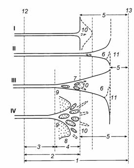
Figure 1. Scheme of river mouth areas of different types and
their subdivisions into the parts.
I – simple river mouth area, II – semi-enclosed river mouth area without delta;
III – semi-enclosed deltaic river mouth area with filling (or bayhead) delta; IV – open deltaic river mouth area with
protruding delta. 1 – river mouth area, 2 – mouth reach of the river, 3
– part of the river mouth reach above the delta head (near-delta reach), 4 – delta, 5 – open nearshore zone, 6 –
semi-enclosed coastal water body (narrow sea bay, liman,
lagoon, estuary), 7 – filling (bayhead)
delta, 8 – protruding
delta, 9 – delta head (delta apex), 10 – subaquatic channel, 11 – blocking spit,
12 – river (upper) boundary of the river
mouth area (head of the river mouth), 13 – sea boundary
of the river mouth area
In the second part of the 20th century, many rivers in the world were subjected to significant human-induced reduction in water runoff and especially sediment yield. At the same time, relative sea level rise (RSLR) was observed in many sites along ocean coasts. In addition, relative increase in impact of tides, storm surges and sea waves was revealed.
These changes in governing factors had an important impact on evolution and regime of river mouth areas [Mikhailov, 1997b; 1998; Mikhailov and Mikhailova, 2003; Mikhailov et al., 2004; Mikhailova, 2006].
PECULIARITIES
OF EROSION AND DEPOSITION AT RIVER MOUTHS
The physical basis for changes in alluvial fans including deltas at river mouths is the disturbance of the relationship between sediment budget components.
Let us consider the equation of sediment budget at a river mouth in the most general form:
Win – Wout = ΔWaf, (1)
where Win is the sum of all incoming components of sediment budget at the river mouth for a time interval Δt at the external (riverine and marine) boundaries of the mouth area; Wout is the sum of all outgoing sediment budget components for the time Δt at the same boundaries, ΔWaf is the change in the volume of the mouth alluvial fan (including the delta) for the same time interval (the resulting term of the sediment budget equation).
The incoming component of equation (1) Win comprises the volume of sediments Wr delivered by the river; the volume of marine sediments Ws delivered by longshore drift into the mouth alluvial fan:
Win = Wr + Ws. (2)
In their turn, Wr comprises the volumes of fine suspended sediments and more
coarse bed load sediments (most often, sand fractions with a mean diameter of
more than
The outgoing budget component of equation (1) Wout comprises the volume of coarse sediments Ww, carried out of the delta coastline by waves, and the volume Wdeep of mostly fine sediments carried by currents out of the mouth alluvial fan into deeper parts of the sea:
Wout = Ww + Wdeep. (3)
Many deltas are protruded into the sea and are subjected to moderate or strong abrasion effect of waves, and serve, as a rule, as a source of sediment supply to the longshore sediment drift, rather than an interception zone. Therefore, commonly we have Ww > Ws.
The volume of fine sediments carried out into deeper zones beyond the river mouth area Wdeep commonly does not allow direct evaluation, so it is calculated either by the method of analogy or as a residual term in the full equation of sediment budget at river mouth.
Of greatest importance is the estimation of changes in the volume of the mouth alluvial fan ΔWaf, though this estimation is the most difficult. The value of ΔWaf for time interval Δt comprises the changes in the volume of the accumulative body of the delta ΔWd and changes in the volume of the accumulative body in the nearshore zone ΔWnz:
ΔWaf = Wd + ΔWnz. (4)
The value of ΔWd, in its turn, comprises changes within time interval Δt of the three main components:
1) the total volume of channels of delta branches due to its erosion or, vice versa, silting and artificial withdrawal (quarry development) of sands for economic needs;
2) the volume of deposition of fluvial sediments (commonly fine) on the surface of the delta plain and in deltaic lakes during river floods;
3) the volume of sediments ΔWΔH deposited on the surface of the delta because of a level rise by ΔHs in the receiving water body within time interval Δt; ΔWΔH is the volume of the prism (it will be referred to as backwater prism) that can be filled by riverine sediments (if they are available in a sufficient amount); the potential volume of the prism ΔWΔH is proportional to the value of ΔHs and the area F'd of the part of the delta that is inundated by sea waters:
ΔWΔH ~ 0.5ΔHs F'd. (5)
The volume of sediments deposited
in the nearshore zone ΔWnz can be evaluated either from measurements
(bathymetric surveys) in this zone or by using the approximate geometric model
of changes in the accumulative body in this zone for example as follows [Mikhailov et al., 1986; Mikhailov
and Aleshkin, 2004; Mikhailova,
2006]:
ΔWnz ~ ΔL Bdcl (hnz + 0.5 ΔHs), (6)
or
ΔWnz ~ 0.5ΔL2Bdcl![]() . (7)
. (7)
In (6) and (7) ΔL is the distance of delta progradation into the sea within time interval Δt, Bdcl is the length of the delta coastline, hnz is the mean depth of the nearshore zone, ΔHs is the change in sea level within the same period, i0 is slope of initial sea floor near the coastline, and ib is marine slope of the mouth fan (or mouth bars of main delta branches).
Let us derive an universal sediment budget equations in the mouth area of a river with a protruding delta and a deep and open nearshore zone (fig. 2a) simultaneously suitable for three main cases: at a relatively stable sea level (fig. 2b), rising sea level (fig. 2c), and dropping sea level (fig. 2d). We will take into account only the most important and significant components of sediment budget, and use more simple formula (6) for ΔWnz:
ΔL ~ ![]() (Wr – Ww
– Wdeep
– 0.5 ΔHs
F'd). (8)
(Wr – Ww
– Wdeep
– 0.5 ΔHs
F'd). (8)
As follows from (8), the greater Wr and the lesser the length of the delta coastline, the depth in the nearshore zone, and the affect of sea waves, the greater the rate of delta progradation into the sea.
As follows also from (8), the delta will prograde into the sea (ΔL > 0) only when Wr > (Ww + Wdeep + 0.5 ΔHs F'd). However, when river sediment yield is not sufficient to fill the «backwater prism» 0.5 ΔHs F'd at rising sea level and to compensate for the sediments being carried out of the delta Ww + Wdeep, the delta will be partially inundated by sea waters and destroyed by waves (fig. 2c).
The progradation of the delta into the sea (both active and passive) at dropping sea level grows if the river sediment yield and the value of sea level fall increase, but the depth in the nearshore zone decrease (fig. 2d).
REGULARITIES
OF DISTRIBUTION AND REDISTRIBUTION OF RIVER WATERS AND SEDIMENTS WITHIN MOUTH
AREA
Processes of water and sediment distribution and redistribution between different parts of the mouth area, including delta and nearshore zone, play a very important role in water supply of the mouth ecosystems and morphological changes of the mouth and its parts.
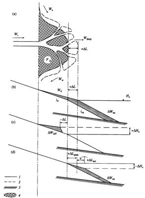
Figure 2. Scheme of a protruding delta (a) and variations in the longitudinal profile of a mouth alluvial fan at stable (b), rising (c), and dropping sea levels (d). (1) and (2) are initial and final positions of the surface of water, land, bottom, and shoreline, (3) is the initial bottom of the sea, (4) is surface of the delta [Mikhailova, 2006]
Distribution of water discharges Q between delta branches depends on hydraulic resistance of channels and their systems according to equation
![]() ,
(9)
,
(9)
where F is cumulative modules of hydraulic resistance of channel system (i or j). It can be calculated using equation
 , (10)
where Fi.0 is modules of hydraulic resistance of main (feeding) channel of the system i, Fi,l and Fi,r are cumulative modules of hydraulic resistance of left and right channel subsystems forming system i. They also can be calculated using equation of the type (10).
Modules of hydraulic resistance of the individual delta channel between two adjacent junctions equals
![]() (11)
(11)
where l, B, h are channel length, width, and mean depth respectively, and n is its roughness coefficient.
Combination of equations (9) – (11) shows that changes in l, B, h, n of delta channels due to their transformation both natural (erosion, silting, channel progradation into the sea or shortening, etc) and artificial (channel deepening, damming, strengthening, etc) necessarily must lead to changes in water discharge distribution between delta branches. For example, erosion in the channel, its artificial deepening, natural or man-made shortening lead to increase of the fraction of its water and sediment discharges in the delta and to decrease of analogous fraction in adjacent channel. In contrast, silting of given channel, its natural or man-made lengthening (including progradation into the sea) cause decrease of the fraction of the river water and sediment discharges in this channel and increase in the adjacent one.
Distribution of sediment discharges between delta branches usually is approximately in proportion of water discharge distribution. But in active channels subjected to erosion, the share of the sediment discharge is, as a rule, more than the share of the water discharge; in passive channels with predominate deposition the situation is converse.
Above-mentioned processes of water and sediment redistribution within the delta lead, in turn, to changes in water and sediment supply of different parts of the mouth area, including delta and nearshore zone, to large-scale erosion or deposition in delta channel systems. As a rule, delta branches increasing their water and sediment discharges are the most active, and have the tendency to erosion and progradation into the sea. Delta branches which decrease their water and sediment discharges became passive and have the tendency to silting or even dying out; near their mouths delta coastline can be subjected to abrasion and retreat.
Methods of mathematical modelling of combined processes of hydraulic and morphologic changes in river deltas were presented in [Mikhailov et al., 1986; Mikhailov, 1998; Mikhailov and Aleshkin, 2004]. In framework of these methods, evaluation of erosion and deposition in delta branches is based on the concept of tendency of channels to dynamic equilibrium.
SEDIMENT
BUDGET AT RIVER MOUTHS
River mouths represent places of large-scale deposition of river sediments [Deltas–models…, 1975]. Some new estimates of sediment budget at river mouths were made in [Mikhailov et al., 2006]. Investigations show that trapping capacity of river mouths (including deltas and nearshore zone) depends on wide range of feature of river mouths, river and sea regimes. Among them, the greatest importance are the type of the river mouth as a whole, the types and sizes of the surface of the delta plain, sea level changes, influence of waves and tides, etc.
The most part of river sediments is trapped at
semi-enclosed river mouths, which have large lagoons and limans.
In mouth areas of the Ob, Yenisei, South Bug,
Large present-day river deltas under natural conditions
trap from 50 to 75% of river sediments (deltas of the Lena, Indirigka,
Calculation shows that value of
river-born sediments which deposited in present-day deltas of the world
represents on average about 40% of the river sediment yield.
Part of the river sediments deposited in the nearshore zone of the river mouth areas comprises approximately 45% of the full river sediment yield. This fraction increases with growth of the accumulative body in the nearshore zone and with decrease of the influence of waves, tides, storm surges, and longshore currents.
As a whole, river mouths areas in the world trap on
average 85% of the river sediments. This value comprises about 15∙109
t per year. The rest part of the river sediments (15% or about 2.6∙109
t per year) removes beyond river mouth areas with longshore
drift (coarse sediments) or with sea currents to deep marine depths (fine
sediments). Some part of river sediments can
be deposited on the surface of the huge deep-sea cones, such as the Ganges cone
(or
DYNAMICS
OF PRESENT-DAY RIVER MOUTHS
Large-scale changes in the sea-level is the most important factor determining evolution of the river mouths on the ocean and sea coasts. Vast rise of the sea level leads to inundation of lower parts of the river valleys and low-laying sea shores, and to formation of semi-enclosed coastal water bodies. During this phase of the sea level changes formation of estuaries, lagoons and limans predominates. Deltas are mainly formed during phases when the sea level drops or is relative stable. Alternating of above-mentioned phases in the sea level changes leads to large-scale river mouth transformation. River sediment yield is additional important factor influencing these processes.
Estuaries, lagoons, and limans were formed as a result of the sea level rise during the Holocene marine transgression. If river sediment yield was large or moderate, these semi-enclosed coastal water bodies can be completely or partially filled with river sediments and be converted into filling (bayhead) or protruding deltas. If river sediment yield was small and erosion influence of tidal currents was strong, semi-enclosed coastal water bodies can retain their specific estuarine features.
At present coastal water bodies of the estuarine type are subjected to the following hydrological-morphological processes:
·
They are slowly
silted with riverine and marine sediments. This
deposition in many cases is retreated by human-induced reduction in river
sediment yield and by impact of the sea level rise and tidal currents. But in
the heads of the Gironde (
·
Artificial
deepening of estuaries and their improvement by construction of embankments and
jetties for navigation needs lead to erosion in main channel and silting of
peripheral parts of the estuaries (the Seine, Gironde,
Loire,
The majority of large deltas in the world began to be formed 5–8 thousand years ago, when the sea level slowed down its rise or became stable. Subsequently delta formation process depended on climatic and human-induced changes in river water runoff and sediment yield. The last active progradation of the deltas into the oceans and seas was observed during the 17–19th centuries, when cold and wet climatic conditions took place and river sediment yield increased as a result of erosion in river basins due to deforestation and ploughing up the lands.
The most rapid progradation of deltas into the seas occurred at the Huang He and Amudarya river mouths and comprises 10 km/year and 4 km/year respectively; delta growth ranged here up to 42 km2/year and 22 km2/year correspondingly [Mikhailov, 1997b; Mikhailova, 1998].
Vast progradation of the
In the middle of the 20th
century situation sharply changed. Progradation of
many deltas of the world into the oceans and seas slowed down or was subjected
to retreat and degradation in response to significant reduction of river
sediment yield due to reservoir construction and river flow regulation.
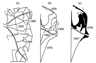
Figure 3. Scheme of variations
in the Chilia delta at the Danube mouth in 1830–1980
(a), the Sulak delta in 1862–1978 (b) and in
1978–1997 (the shadowed zone is the delta area inundated by the sea
waters and eroded by waves) (c); the Sulak spit in
1978 (1) and 1997 (2) [Mikhailova, 2006]
Present-day
hydrological-morphological processes in river deltas can be summarized as
follows:
·
Delta coastline at the majority of river mouths is subjected to strong
or moderate abrasion. The most vast retreat of the
delta coasts is observed at the mouths of the Nile,
·
In many deltas, redistribution of river waters and sediments in favour
of artificially deepened large delta branches takes place. Other small and
secondary delta channels are subjected to silting or even to dying out.
·
In many deltas only large, deep and water-abundant delta branches prograde into the sea, for example, the Pila
branch in the Po delta, the Bystriy branch in the
Danube delta, the Qingshuigou branch in the
·
Abrasion and retreat of delta coastline at many river mouths is
stimulated by relative sea level rise (RSLR). Eustatic
component of the RSLR at the mouths on the ocean coasts comprises presently
about 2 mm/year. Additional impact on the RSLR is given by subsidence of
deltaic deposits due to their natural consolidation or extraction of ground
waters, oil, and gas. Subsidence can reach in the deltas of the Po,
·
Delta formation processes on the coasts of large lakes can be subjected
to significant influence of the large-scale changes of water level [Mikhailov, 1997b; Mikhailov et al., 2004; Mikhailova,
2006]. For example,
rapid progradation of the Sulak
delta into the
Conclusions
River mouth areas (river mouths) are very changeable
and vulnerable geographical objects. Alternation of their structure, regime and
landscape is governed by internal hydrological-morphological processes
depending on changes of external river and sea factors. Among these factors
natural and human-induced changes in river water runoff and sediment yield and
sea level are the most important. Presently basic tendency of changes of river
mouths in the world consists in decrease of impacts of riverine
factors and increase of marine ones (human-induced reduction of river sediment
yield, relative sea level rise, increase of wave action). Many deltas slowed
down their progradation into the sea; abrasion of
their coastline increased. Filling with sediments of many estuaries and lagoons
decreased. These processes can be strengthened due to expected rise of the
ocean level. According to the IPCC reports, since 1990 this level can rise by
· Zoning of the river mouths for different branches of economy (for example, separately for agriculture and fishery) and for specific protected areas (for example, for natural reserves of wild life and national parks).
· Artificial redistribution of river waters and sediments between different parts of the river mouth area using a system of water distributors, water intakes, and canals, by construction of dykes, embankments, man-made levees, and jetties. The most simple method of large-scale redistribution of river discharges within delta consists in deepening, improvement, and canalization of selected delta branches.
· Defense of the most important social and economic objects using different hydrotechnical measures.
· As a scientific basis of above-mentioned measures should be extensive studies of hydrological-morphological processes in different river mouth areas, working out methods of their computation and prediction, and development of systems of a permanent monitoring of mouths processes.
Acknowledgments
This study was supported by the Russian Foundation for
Basic Research (project № 05-05-65110).
References
Deltas–models for
exploration, ed. by M.L. Broussard, 1975.
McDowell,
D.M., and O’Connor, B.A., 1977. Hydraulic behavior of estuaries,
Mikhailov, V.N., 1997a. Hydrological processes at river mouths,
Mikhailov, V.N., 1997b. River mouths
of
Mikhailov, V.N.,
1998. Hydrology of river mouths.
Mikhailov, V.N., 2004. Principles
of typification and zoning of river mouth areas
(analytical review), Water Resources,
Vol. 31, № 1, pp. 1–10.
Mikhailov, V.N. and
Mikhailov, V.N., Kravtsova,
V.I., Magritskiy, D.V., Mikhailova,
M.V., and Isupova, M.V., 2004. Deltas of the Caspian rivers and their response to changes of the sea level, Caspian Sea Bulletin, № 6, pp. 60–104. (In
Russian).
Mikhailov, V.N., Magritskiy,
D.V., Mikhailova, M.V., 2006. Water and sediment
budget at river mouths, Makkaveev’
Mikhailov, V.N. and Mikhailova,
M.V., 2003. Deltas as indicators of natural and human-induced changes in the
regimes of rivers and seas, Water Resources,
Vol. 30, No 6, pp. 602–612.
Mikhailov, V.N., Rogov,
M.M. and Chistyakov, A.A., 1986. River deltas, hydrological-morphological processes,
Mikhailova, M.V., 1998. The hydrological regime and
dynamics of the mouth of Huang He River, Water Resources,
Vol. 25, No 1, pp. 105–117.
Mikhailova, M.V., 2006. Sediment
budget at river mouth and formation of deltas at rising or falling sea level, Water Resources, Vol. 33, No 5, pp. 567–579.
Officer,
Ch.B., 1976. Physical
oceanography of estuaries (and associated coastal waters).
New-York, A Wiley-Interscience
Press, 465 p.
Samoilov, I.V., 1952. River mouths.