Influence OF reservoirS ON SEDIMENT TRANSPORT AND
EROSION PROCESSES BELOW THE DAMS
85-428
Introduction
For almost 5.000 years man has influenced river
systems by building single dams or multiple dams in cascade systems. This
practice has been the most visible sign of
human interference in the fluvial environment. Each barrier applied to a river
bed causes direct and usually irreversible changes within and outside the ecosystem.
The river channel partition by
the dam effects on one side by the stoppage of sediment transport, represented
by suspended- and bed load ‑ accumulated in reservoir, and on the other,
renewal it’s on the way of the channel-bed erosion below the dam. With intense erosion process downstream from the dam are usually
associated channel transformation caused by sediment transportation, divided on
two parts. The first area takes the form of
a newly created flood-plain associated with the area of erosion. The second
one, below the front of an erosion wave, attributes an aggradation character to
that section of the river bed. The both opposite processes create new ecological
conditions, not always favourable for natural environment and management.
The explanation of reasons and effects stoppage of sediment transport by dams is the main aim of the paper. Moreover, the qualitative and quantitative channel changes below the dams are considered. The influence of channel transformation on economy and ecology were presented.
The study of channel processes is based on the interpretation of air photographs, large-scale setting-altitude maps, bathymetric maps, cross-sections and longitudinal profiles of channel bed and water level. The statistic method and method of successive comparison have been used.
Moreover, the analyze of fluvial processes below the dams based on literature, mainly: A.B. Veksler and V.M. Donenberg (1983), G.P. Williams and M.G. Wolman (1984), S. Raynov, D. Pechinov and Z. Kopaliani (1986), A.B. Avakian, V.P. Soltankin and V.A. Sharapov (1987), on the background of 35. years investigations in Wloclawek Reservoir (Babiński, 1982, 1992, 2002).
Hydrological
regime
The main task of dams is water retention and
regulation of its current intensity. As a result, the annual amplitude of
fluctuation of water level in a reservoir is lowered. Research carried out by American
scientists has shown (Williams and Wolman, 1984) that the average annual high
water level of 21 rivers studied dropped from 3% to 91% ‑ an average of
39% . However the
so-called 5% water culmination was not reduced. As regards the Naser Reservoir
(Raynov et al., 1986), it can accumulate up to 47% of the
The operation of barrages usually influences the daily
fluctuations of water level within a range of 0.5-
Reservoir
sedimentation
The building of barrages is inseparably associated
with the process of accumulating bed-load and suspended-load in a reservoir.
The amount of load subsumed by a reservoir and particularly the rate of flow
intensity to tank capacity is essential factors when estimating its endurance. Research carried out on
sedimentation showed that the amount of deposited load ranges from 80% in the
Garrison Reservoir (the
The sedimentation process leads to the loss of
retention properties of reservoirs. The location and the kind of accumulated
load affect the ecology and management of dams. The higher part of a reservoir
constantly becomes shallower owing to the alluvial cone in the back flow area.
Subsequently, abrupt changes develop in the hydrodynamic features of the river,
making its outflow difficult. In favourable conditions the homogenous mass of
water can split into several arms winding among emerging or submerging alluvial
sandbanks. Some perceive the new hydromorphological situation in the back flow
area as a positive phenomenon, while others claim that it is harmful to economy.
Sedimentation processes help to form new settlements friendly to the local
river fauna, hydrophilic animals and fish. This is regarded as a positive
feature and an argument for justifying the building of reservoirs. As regards
the negative influence, accumulation of the bed-load has the most harmful
effect within the higher part of a reservoir. The shallow and very dynamic bed
can make proper floating difficult or even impossible. Moreover, the constant
“rising” of a bed reduces the area of a river or a reservoir cross-section.
Hydrotechnical buildings built before the water was dammed up can be destroyed
during a freshet. A result can be flooding, which would not occur with a “real”
river. This fact is better illustrated in climatic zones susceptible to
ice-jam. In favourable conditions, brash
ice jams can dam up water above the safety level. The hydrotechnical buildings are then damaged and the previously safe regions
become flooded. Such a disaster occurred in the proximity of the
Włocławek Reservoir in the winter of 1982.
Channel
incision below the dams
When flowing through a reservoir, water loses its clastic load. This is a direct cause of deep-seated erosion below dams (Babiński, 2002). This erosion varies in time and space and is estimated by the speed with which the river bed lowers and by the extension of the erosion area. In general we observe that these two processes slow down. In other words, erosion expands most dynamically at an early stage of the operation of dams and in their proximity. This observation is valid for the majority of dams discussed in this paper. However, a more detailed analysis suggests that the process is more complex. It has been found that there is a period of abrupt changes in a river bed attributable to the building of a dam. When water begins to fill a reservoir, the process of deep-seated erosion slows down but resumes when the reservoir is full. As time passes, the erosion process is increasingly modified by geological conditions of the river bed, by the local hydrographical and morphological net of the area and by man’s economic activity.
In all measured cases of
channel incision below dams (tab. 1), the process was faster in the first years
of damming up water and in the proximity of the dams. This
was the period when the river beds lowered. Research into the American rivers showed they
were lowered by
An analysis of cross-section profiles of the American
rivers helps to estimate the most frequent extreme depth of deep erosion in
cross-sections of river beds, ranged from 2 to
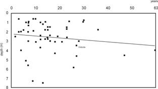
Figure 1. The rate of deep erosion below the dams, after data presented in Table 1 (average in cross-profile in metres) and their straight regression
Complete presented in Z. Babiński (2002)
For a more comprehensive
definition of deep erosion, it is necessary to examine the extent of the
erosion area (the front of erosion zone) and the speed (shifting) of its
advance. Although the extension of the erosion area is the most dynamic in the
initial period of the operation of dams, it cannot be described as a vanishing
straight line function (Galay, 1983, Raynov et al., 1986, Andrews, 1986, Belyj
et al., 2000), complete presented in Z. Babiński (2002). The process
varies and can be illustrated by the values achieved below the
Włocławek Reservoir (0.7-
Table 1. Channel incision below the dams
|
Lp. |
River, dam
(reservoir), region (state) |
Term of observation
(years) |
Degradation
in cross-profile (m) |
|
1 |
|
9 |
7.3 |
|
2 |
|
13 |
7.5 |
|
3 |
|
26 |
5.8 |
|
4 |
|
27 |
4.6 |
|
5 |
|
18 |
3.1 |
|
6 |
Jemez, |
12 |
2.8 |
|
7 |
|
30 |
0.9 |
|
8 |
|
36 |
1.8 |
|
9 |
|
23 |
1.7 |
|
10 |
|
23 |
2.6 |
|
11 |
|
19 |
2.5 |
|
12 |
Medicine Creek, |
3 |
0.6 |
|
13 |
Middle Loup, |
16 |
2.4 |
|
14 |
|
9 |
1.9 |
|
15 |
Smoky Hill, |
23 |
1.5 |
|
16 |
Republican, |
7 |
0.9 |
|
17 |
|
27 |
3.4 |
|
18 |
North Canadian, |
28 |
3.0 |
|
19 |
Canadian, |
6 |
5.1 |
|
20 |
Red, |
16 |
3.0 |
|
21 |
Neches, Town Bluff, |
14 |
0.9 |
|
22 |
Chattahoochee, |
15 |
2.6 |
|
23 |
South Canadian, |
7 |
3.0 |
|
24 |
Salt Fork, |
9 |
0.6 |
|
25 |
|
15 |
1.8 |
|
26 |
An Sabee, Foote Sariyar ( |
15 |
1.5 |
|
27 |
|
13 |
1.2 |
|
28 |
|
16 |
1.5 |
|
29 |
|
12 |
2.4 |
|
30 |
Huang He, |
4 |
4.0 |
|
31 |
Syr-Daria, Farchacka |
7 |
1.3 |
|
32 |
|
60 |
4.0 |
|
33 |
|
7 |
5.6 |
|
34 |
Isar, Dingolfing |
14 |
2.8 |
|
35 |
|
10 |
0.6 |
|
36 |
Saalach, Reichenhall |
47 |
4.6 |
|
37 |
Wertach, Schwabmunchen |
5 |
1.8 |
|
38 |
|
12 |
1.0 |
|
39 |
Danube, |
14 |
1.8 |
|
40 |
Rhein, Gerstheim |
1.5 |
2.5 |
|
41 |
Vistula, |
27 |
3.5 |
After: G.P.Williams and M.G.Wolman (1984),
V.J. Galay (1983), S. Raynov et al. (1986), E.D.Andrews (1986) – selected:
detail in: Z. Babiński (2002)
The average annual speed of
erosion is used as the criterion to compare the rivers in the study. For a period of 1.5 to 54 years the speed varied from
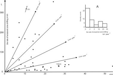
Figure 2. The rate of erosion zone shifting (km per year); A – quantity events in respective erosion zone shifting group
After: V.J. Galay (1983), S. Raynov et al. (1986) and E.D. Andrews (1986), B.V. Belyj et al. (2000); complete presented in Z. Babiński (2002)
Morphological
and sedimentological consequences of channel incision below the dams
Deep erosion is responsible for the morphological transformations of the valley bottom. The process takes place in two areas of accumulation. The first area takes the form of a newly created floodplain (integrated from “old” floodplain, island and fixed sand bars) associated with the area of erosion zone (Fig. 3). The second one, below the front of an erosion wave, attributes a aggradation character (channel pattern – braided) to that section of the river bed. Newly formed floodplain is not only new “land” but it also provides good living conditions for water fauna. The lower a river bed descends, the more advantageous the process. This is because freshets flood the area on fewer occasions and there are smaller daily fluctuations. It should be noted that the unidirectional development of the floodplain and the area of river current below the dam make the system more stable. In many cases of rivers below the dams, the formerly braided channel has adopted a single-thread meandering pattern or straight pattern limited by groynes (Babiński, 2002, Habel, 2007).
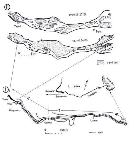
Figure
3. The plan view of the Lower Yellow
River downstream from Sanmenxia reservoir to
After: I –
Channel incision below dams is frequently accompanied
by a change in particle size on the bed, as gravels and fine materials are
winnowed from the bed and transported downstream, leaving an armour layer, a coarse
lag deposit of large gravel, cobbles, or boulders (in case of
Włocławek Reservoir – silt and clay. Development of an armour layer
is an adjustment by the river to changed conditions because the larger
particles are less easily mobilized by the “hungry” water flows below the dam.
The armour layer many continue to coarsen until the material is no longer capable
of being moved by the reservoir releases or spills, thereby limiting the ultimate
depth of incision (Williams and Wolman 1984, Dietrich et al. 1989). If the
armour layer is thin, then is possibility to catch it and renewal a channel
incision. This process is very dangerous for dam existence, an example of
Ecological
and economic effects of reservoir creation
By dividing river beds with dams, man creates barriers for water wildlife and marks boundaries for numerous ecological and economic processes. Important reactions result from the reservoirs above dams and the erosion below them. Usually the formation of a new, a biotic environment outpaces the development of the natural biotic environment and man’s economy. While reservoirs have some positive economic effects (outflow regulation, ecologically “friendly” electricity power, roadway passages), in general they have a negative influence on environment. Governments have found it necessary to review their attitudes towards the building of dams, particularly those damming up high waters. This new attitude aims to regain the natural habitat around the hydrotechnical buildings.
By the use of modern hydrotechnics in connection with
ecology a very effective method has been devised to reduce the negative impact
of dams and water barriers. The idea is to regain the natural state of river
beds by incorporating some new hydrological systems into the water cycle. This
method is usually applied to the highly degraded surfaces of the beds of river
valleys which form embankment areas. The so-called Giessgang near Greifenstain
on the Danube (
Several methods can reduce or even eliminate the negative influence of the bed-load on the economy. One is to dredge at the level transported by river alluvium. Another, when only the upper reservoir is endangered by sedimentation, is to build a cascade system. Other recent measures to reduce the process have been to lower reservoir thresholds and to induce artificially high waters. At certain times and in favourable hydrological conditions these measures can help to move the river bed material away from the reservoirs. However, when the whole of the river basin is a consideration, the speed of growth of the alluvial cone in a reservoir can be decreased only by limiting the size of load deposited in the headwaters.
Conclusion
The river channel partition by the dam always effects by the stoppage of sediment
transport, accumulated in reservoir and renewal it’s on the way of the
channel-bed erosion below the dam. The channel erosion is increase by 24-hours
fluctuation of water level, caused by electro-power-station work. Research carried out on reservoirs
sedimentation showed that the amount of deposited load ranges from 80% to 99.5%
of total clastic material. In the Włocławek Reservoir, total load
amounts to 90%, of which 100% is the bed-load and over 41% the suspended load.
The renewal of suspended- and bedload transport below
the dam occur on the way of deep erosion, as shown in Table 1 and Figure 1, and
effects by lowering of river bed (average in cross-profile) from
With the intense erosion process downstream from the dam are usually associated channel transformation caused by sediment transportation, divided on two parts. The first area takes the form of a newly created floodplain associated with the area of erosion. The second one, below the front of an erosion wave, attributes an aggradation character to that section of the river bed.
References
Andrews
E. D., 1986. Downstream effects of Flaming Gorge
Reservoir on the Green River, Colorado and Utah, Geol. Soc. Am.
Bull., 1012-1023.
Avakian
A. B., Soltankin V.P., Sharapov V.A., 1987. Vodochraniliszcza,
“Mysl`”, Moskwa
Babiński
Z., 1982. Procesy korytowe Wisły poniżej zapory
wodnej we Włocławku, Dok. Geogr., 1-2.
Babiński
Z., 1992. Współczesne procesy korytowe dolnej
Wisły, Prace Geogr., 157.
Babiński, Z., 2002, Wpływ zapór na
procesy korytowe rzek aluwialnych ze szczególnym uwzględnieniem
stopnia wodnego “Włocławek” (Sum.: Influence of reservoirs on fluvial
processes of alluvial rivers with particular regard to the Wloclawek Reservoir,
Wydawnictwo Akademii Bydgoskiej,
Bydgoszcz, Poland.
Belyj B.
V.,
Berkovich
K. M., 1992. Regulirovanije recznych rusel,
Izdat. Moskovskogo Universiteta, Moskwa.
Chien N.,
1985. Changes in river regime after the construction of
upstream reservoirs, Earth Surface Processes and Landforms, 10,
143-159.
Chiwei
Dietrich
W.E., Kirchner J.W., Ikeda H., Iseya F., 1989. Sediment supply and development
of coarse surface layer in gravel bedded rivers, Nature, 340, 215-217.
Donaukraft, 1996. Das
Donaukraftwerk Freudenau und seine Rolle in der Wasserwitschaft des Wiener
Donauraumes, Unterlagen zum Workshop,
Verbundplan ‑ Donaukraft Engineering, Wien.
Galay V.
J., 1983. Causes of river bed degradation, Water
Res. Research, 19, 5, 1057-1090.
Graf W.
L., 1980. The effect of dam closure on downstream rapids,
Water Res. Research, 16, 1, 129-136.
Habel
M., 2007. Fluvial processes below the
Raynov
S., Pechinov D., Kopaliani Z., 1986. River response to
hydraulic structures, (red.: R.D. Hey), International
Hydrological Programme, UNESCO, Paris.
The
Three Gorges Project, 1994. Changjing Water Resources Commission, China
Yangtze Three Gorges Project Developmenr Corporation,
Veksler
A. B., Donenberg V. M., 1983. Pereformirovanie rusla v
niżnich befach krupnych gidroelektrostancij, Energoatomizdat,
Moskva.
Williams G. P., Wolman M. G., 1984. Downstream effects of dams on alluvial rivers, Geol.Survey Profes.
Paper, 1286,