Hydroecological safety of
N. I. Alekseevskiy, R. S. Chalov
Department of Hydrology,
Faculty of Geography, Moscow State University
Vorobievy Gory, Moscow, Russia, 119992, phone 7 (495)
9391001 n_alex@hydro.geogr.msu.su
Hydroecological safety depends on water sources availability, water quality and
dangerous hydrological processes development. Theirs changes occur under
natural and anthropogenic factors and lead to the risk of social, economic and
ecological damages. Channel deformations are the reason of risk occurrence [Berkovitch etc., 2000]. Their dangerous expressions develop
under changes of hydrological regime, streams hydraulic characteristics, water
and sediment runoff because instability of channel deposits, channel forms and
channels themselves is caused by natural or anthropological shifts of stream
velocities, water and sediment discharges.
The relationship between sediment yield and channel deformations is explained by the equation of sediment mass balance for the channel reach
W2 – W1 = ±DW, (1)
where W2 and W1 are the sediment loads on the downstream and upstream reach borders, DW is the balance resultant. If the lack of sediment supply by tributaries and from slides exists, DW depends on the volume of river (floodplain and channel) deposits changes DW0:
![]() .
(2)
.
(2)
The eq. (2) shows that the resultant of sediment mass balance and river deposits are equals with contrary sign [Alekseevskiy, 1998]. Under the longitudinal sediment load increase the value of DW > 0. This process is determined by erosion of river sediments (channel banks and/or beds) and accompanied by theirs volume decrease DW0. Sediment volume decrease is expresses by vertical deformations and bottom level drop or horizontal deformations and bank erosion [Chalov, 1979]. Opposite processes occur under the longitudinal sediment load decrease (DW < 0). The increase of river sediments exists (DW0 > 0). In this case the vertical deformations correspond to bottom level increase, horizontal – to the deposition on floodplain banks. When the sediment particles are transported along the channel reach (at the equality of deposited and entrained sediments, when DW = 0) the volume of river sediments is constant (DW0 = 0) and stable channels exist [Karaushev, 1977]:
Wsl = W, (3)
where Wsl is
transporting capacity. It equals to the rate of sediment yield, possible to
transport in each time interval i of
the representative period T under certain
annual water regime and stream hydraulic characteristics. Thus, Wsl depends on flow rate and is characterized by suspended sediment concentration ssl corresponded to the maximum sediment load under
certain hydrological and hydraulic characteristics.
In stable channels bed and bank deformations have lack
of directed development (fig. 1a) and are expressed only in geological time
scale. For the unstable channels the eq. (3) is
disturbed because of natural and anthropogenic transformations of sediment
yield W and transporting capacity Wsl. In each
case there are 2 possible variants of deformations development. If the increase of Wsl and
decrease of W induce the existing of Wsl >W, the ![]() could be removed by the sediment yield increase
and transporting capacity decrease. It occurs by the
channel deformations process. Because of bed
and bank erosion the balance resulting DW>0 and decrease of channel deposits volume appears. The maximal
intensity of channel deposits diminution occurs near the upper reach border. As
the result the channel slope decreases, what is the factor of transporting
capacity reduction. The equality (3) is achieved.
could be removed by the sediment yield increase
and transporting capacity decrease. It occurs by the
channel deformations process. Because of bed
and bank erosion the balance resulting DW>0 and decrease of channel deposits volume appears. The maximal
intensity of channel deposits diminution occurs near the upper reach border. As
the result the channel slope decreases, what is the factor of transporting
capacity reduction. The equality (3) is achieved.
The opposite processes develop at the reaches with Wsl <W. This inequality reflects the sediment load yield increase or transporting capacity reduction. Accumulation processes occur and Wsl grows and W decreases. The maximal sediment accumulation is observed near the upper reach border where the volume of sediment deposits increases (DW0>0). Bed level grows with higher intensity. Sediment load discharge reduces, channel slope and transporting capacity decrease and finally the new state of the “channel-water stream” system leads to the eq. (3).
Figure 1. The response stable stream-channel system to sediment load yield increase: reduction (b) or growth (c) of transporting capacity
Channel processes influence on the social and economic
safety and nature management is controlled by sediment yield and transporting
capacity factors shift. River sediment yield includes suspended load yield (WR) and bed load yield (WG).
Sediment yield components depend on river size and geographical conditions of
river basin determining erosive processes intensity [Sediment yield, 1979; Dedkov, Mozherin, 1984]. When
other factors are similar the stream order increase is accompanied by suspended
and bed load yield growth.
Channel deformations intensity controls risk of
engineering objects damage, water intake shoaling, the riparian lands losses
and depends on WG/WG+R ratio.
It varies in wide ranges in according to changes of sediment yield components [Chalov, Lui Shuguang,
2005]. On the North Russian rivers the relatively small sediment yield is
combined with WG/WG+R = 40–50% and more. It is the consequence of
forest cover and poor erosive processes. Only incised channels with limited
channel deformations are stable and channel deformations are safe for most
human activities. Channels with wide floodplains are unstable. On small rivers the annual erosion
velocities are about 1-
Plateaus composed by loess, abundant soil and gully
erosion are the sources of the southern rivers sediments where WG/WR+G
< 10%. The total sediment yield is 2–3 times more as northern rivers.
Bed load materials are the only channel forming sediments in the North. In the
South the main part of the suspended load materials is also channel forming
sediments. It determines the instability of southern rivers, intensity of
horizontal deformations (10–100 m/year), bed level shifts because of large riffles
movement up to 100–1000 m/year and as a result the high risk of water resources
use (Terek, Kuban and Ob
rivers in Russia). Sediment yield and transporting capacity are transformed because
of evolution of river systems and changes of basin natural conditions and also
under nature management in river basins and channels. Deforestation, marshes
drainage, mining, riverbed excavation are the main human activities affecting
the suspended sediment load variations. Transporting capacity shifts mainly due
to water runoff (flow) regulation, riverbed excavation and changes of channel
width, depth and length (tab. 1). The impact of hydraulic project and quarries
digging differs between upstream and downstream reaches of works facilities.
Inside-basin and inter-basin water redistribution are also an important
factors. In the rivers – receiving waters transporting capacity increases, in
the rivers – water sources transporting capacity decreases. Wsl and/or W changes are
accompanied by the channel deformation, thus natural management is usually the
reason of damage expressions.
The spatial-temporal scales of
the equation (3) transgression are much different. Global environmental
changes, large hydraulic projects, inter-basin water redistribution,
deforestation are spread over vast territories and river basins in historical
and geological duration. The risk level of main directed channel deformations
is determined by velocity and rate of these changes. Also during natural
evolution of channel forms the eq. (3) may be broken.
As a result the deepening or shoaling of braided rivers branches, the channel
banks erosion or accumulation occur. The same processes exist under human
impact on channels, water runoff and sediment yield. Under the installation of
water reservoirs and mass quarries digging the disturbance of the equality Wsl =W involve
large stream reaches including theirs tributaries; the influence of the single
quarry is exerted over a short reach and leads to the local deformations. In
one case the disturbance of hydroecological safety is
characterized by general or regional and permanent scale, in another – it is
local and brief.
Table 1. Anthropogenic impact on river
sediment movement (Alekseevkiy, 1998)
|
Anthropogenic
impact |
Sediment
yield change factors |
Suspended load
DR and bed load DG yield change |
|||
|
Water discharge
change DQ |
Suspended
sediment concentration change Ds |
s
sтр |
во времени Dt |
по длине (Dx) участка реки |
|
|
Hydraulic projects: upstream
dams downstream dams |
D Q DQ ¹ 0 |
Ds < 0 Ds < 0 |
s > sтр s< sтр |
DR/Dt<0 DG/Dt <0 DR/Dt<0 DG/Dt<0 |
DR/Dx<0
DG/Dx<0 DR/Dx>0
DG/Dx>0 |
|
Channel quarries: upstream downstream |
DQ |
Ds ≥ 0 Ds < 0 |
s £ sтр s < sтр |
DR/Dt DR/Dt<0
DG/Dt<0 |
DR/Dx DR/Dx>0
DG/Dx>0 |
|
Channel cut-off |
DQ |
Ds > 0 |
s < sтр |
DR/Dt>0 DG/Dt>0 |
DR/Dx>0 DG/Dx > 0 |
|
Water redistribution: downstream
water intake Inter-basin redistribution |
DQ<0 DQ>0 |
Ds≥0 Ds>0 |
s>sтр s<sтр |
DR/Dt DR/Dt>0
DG/Dt>0 |
DR/Dx<0 DG/Dx<0 DR/Dx>0
DG/Dx>0 |
The level of channel processes risk depends on the intensity of channel deformations, their directed or recurrent development, frequency of occurrence on each river – on the channel stability as a whole. That’s why the estimation of channel deformations risk is produced according to the channel stability characteristics (tab. 2) – Lohtin number and Makkaveev stability coefficient:
![]() ,
, ![]() ,
(4)
,
(4)
where d is size of channel deposits (mm), I – slope (‰), b – channel width, m.
The impact of channel processes risk on social and
industrial units is assesses by the risk scale from 0 till 5 points. The upper
border (point 5) is absent for the rivers of
The level of channel processes risk depends on channel pattern type. Meandering, braided or relatively straight channels are characterized by the special rules of location of accumulation and erosion areas, during different phases of channel forms development. Because of their evolution the intensity of deformations increases or decreases. Conditions of channel deformations development (geological and geomorphologic) are also an important factor. Incised channels or channels with wide floodplain occur.
In natural conditions the directed vertical
deformations are distinguished by small intensity (mm/year), their results are
expressed during thousands of years. Thus they may be disregarded at hydroeconomic projects. Vertical deformations lead to bed
level shifts according to development of channel forms. Conditions of intensive
vertical deformations are infrequent. In
Table 2. Types of channel processes risk [Berkovitch etc., 2000]
|
Risk of
channel processes (channel
stability) |
Points |
Stability
characteristics |
Channel
deformations characteristics |
||||||
|
L |
ks |
Cг |
Uср |
Umax |
T |
l |
±∆z |
||
|
Very high (very unstable) |
4 |
<2 |
<6 |
>500 |
>10 |
>50 |
3-10 |
>80 |
10-20/2-5 |
|
High (unstable) |
5 |
2-5 |
6-15 |
300-500 |
5-10 |
>20 |
10-20 |
60-80 |
5-10/1-2 |
|
temperate (relatively stable) |
2 |
5-10 |
15-20 |
250-300 |
2-5 |
>10 |
20-80 |
30-60 |
3-5/0.5-1 |
|
low (stable) |
1 |
10-50 |
20-100 |
10-50 |
<2 |
>5 |
>80 |
<20 |
<3/<0.5 |
|
Risk lack (absolutely stable) |
0 |
>50 |
>100 |
<10 |
No erosion |
Stable
channel |
0 |
||
L – Lohtin number; ks
– Makkaveev stability coefficient; Cг – velocity
of large riffles movement (m/year), Uср –
average velocities of bank aggradation (degradation)
(m/year); Umax – maximal velocities of bank
degradation (m/year); T – periodicity
of branches development, years; l – length of
eroded banks, % of river reach; ∆z –
incision (-) / sediment accumulation (+) (in nominator – below dams or channel
quarries; in denominator ‑ in natural conditions)
The vertical deformations become more intense under
the influence of anthropogenic factors. On small rivers siltation
and degradation due to abundant supply of material of surface and gully erosion
occur. On middle and large rivers accumulation develops on lower reaches and
upstream of reservoirs. Bed level growth leads to water level raise, and waterlogging of floodplains. Downstream of hydraulic projects
incision occurs. Channel quarries induce the same effects. Water level decrease
occurs also because of channel deposits excavation. Safety of water intakes,
harbours, underwater communications, bridges is
disrupted. Production of agricultural lands declines.
Water level decrease and river incision are connected with works on navigation protection. Reduction of water level is not great. But realization of these works on long reaches leads to dangerous reduction of water level.
Maximal risk of banks erosion and expression of other
dangerous processes are notified on rivers in the Middle, South, North and East
of the European part of
Siltation and degradation of small rivers is typical for urban areas of

Figure 2. Bank erosion on Russian rivers. Areas: 1 – all-over erosion; 2 – with stable banks; 3 – local bank erosion; 4 – with rocky banks; 5 – with interchange of stable and eroded banks; 6–15 – different channel pattern types. Bank erosion intensity (m/year): 16 – small (> 2), 17 – temperate (2–5), high (5–10), very high (>10); 20 – extremal bank scours
In general the expression of
channel processes risk under natural or anthropogenic changes of sediment yield
and transporting capacity equals
RD = pD, (5)
where p and ×D – probability of channel
processes risk and its damage. When
other factors are similar the channel processes risk is low on rivers with
stable rocky channels. For unstable channels risk increases according to
population density and growth of agricultural
lands area.
Maximal risk is observed in
During the period from 1950 till 1980 years a great
contribution was done to increase navigation depths of Russian rivers (on the Severnaya Dvina river – from
90 to
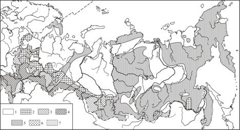
Figure 3. Siltation and degradation of small rivers: 1 – prevalence of rivers in natural conditions; 2 – interchange of silted and non-silted rivers; 3 – upstream siltation; 5 – non-silted rivers of mountain and semi-mountain regions; 6 – rivers with anthropogenic siltation; 7 – undrowned areas. [Berkovitch etc., 2000]
Cessatation or diminution of channel control in the beginning of 1990th led to the rivers shoaling. The depth of many rivers decreased to natural values (for 30–50 cm in average). Possibility of navigation stop occured. At the same time background of other dangerous processes was formed. Stream flattening increased the possibility of ice jams and floods. Sediment accumulation and bed level increase is the reason of water surface levels increase (Q = const) and floods menace. The natural accumulation of the lower Terek and decrease of transporting capacity led to the whole transformation of river network and flooding of urban areas even during low-water period.
Channel processes break the safety of communication passages through rivers. Safety providing is determined by assessment of channel processes under optimal section choice. The most dangerous are the channel deformations. Passage use is safe if the deformations doesn’t have directed development, and gravity processes on the valley slopes are absent. The most dangerous are meander movement and cut-off processes, and on the braided rivers – high rate of deepening or shoaling of branches. The optimal for communication passages are stable reaches. But the threat of pipelines safety and bridges is induced by large riffles movement also. Necessary depth of pipelines and bridges installation to the channel deposits is determined according to riffles size depending on stream order.
The work is supported by Leading
Scientific Schools program (project SS-4884.2006.5), RFBR (Project № 06-05-64293, 06-05-64099) and RFBR-GFEN of
References
Alekseevskiy N.I., 1998. Forming and
transport of river sediments. MSU Publishing House,
Alekseevskiy N.I., 2004б. Ecological hydrology and hydroecology in sciences system // Hydroecology:
theory and practice / Hydrology and hydroecology
problems. Iss. 2. Msu geographical department,
Berkovich K.M., Chalov
R.S., Chernov A.V., 2000. Environmental channel
processes studying, GEOS,
Dedkov A.P., Mozherin V.I.,
1984. Erosion and sediment yield in the World.
Ivanova N.N., Golosov
V.N., Panin A.V., 1996. Urbanization and rivers … at
European part of
Karaushev
A.V., 1977. Theory and estimation methods of river sediments,
Gydrometeoizdat,
Channel processes and water ways of the
Sediment
yield, its studying and geographical distribution, 1979. Gydrometeoizdat,
Chalov R.S., 1979. Geographical researches of
channel processes. MSU Publishing House,
Chalov R.S. Lui Shuguang, 2005. Sediment yield as channel processes factor
(example of Russian and Chinese rivers) // Soil erosion and channel processes. Iss. 15:
MSU Publishing House,